Tuesday, January 27, 2009

Getting To Know: The Province of LAGUNA

THE PROVINCE OF Laguna stretched along the extensive Laguna de Bay is the home of several hot springs, falls and the enchanting Mt. Makiling. Laguna De Bay is surrounded by public resorts facilitated with swimming pools that have water coming from hot springs, which are jammed-pack by visitors during weekends.

Pagsanjan Falls in the town of Pagsanjan, Laguna


A well-constructed road now circles the bay. Driving down this highway leads you to many interesting spots and stunning views. Pagsanjan is the most famous town. Visitors mainly come for the thrilling river ride between the striking canyon walls to Pasanjan Falls. Two boatmen struggle to push the boat upstream against the strong rapids and head further up until water is calm. This pattern is repeated several times up to the falls. With the skill and strength of the boatmen who were paddling the river all their life, a guide and a pilot will safely guide your journey with a little exciting toss and twist through the torrents as boat speeds upstream. Once you reach the falls, a raft will be chartered to take you a hidden cave behind the cascading water. However, during and after a rainy season, heading to the falls is not possible. And when the river is low, “shooting the rapids” ends up “carrying the banca”. With this, you will be charged more by the boatmen, as they will loudly claim how much work they did during the ride.

University of the Philippines in Los BaƱos, Laguna


Los Banos is another town within Laguna and the jumping-off town if you plan to climb Mt. Makiling. The hike is possible via the access road inside the UP Campus. There is a trail heading to some natural hot springs and to the summit.

Lake Caliraya is a refreshing 2 hour drive from Manila. It is a wide man-made lake that was initially constructed to feed the water of Laguna De Bay. Caliraya nestles amidst coconut palms lined up parallel to each other beautifully sited at the foot of Mt. Banahaw. Exciting water activities are unlimited in the area. Most resorts facilitate boardsailing, windsurfing, jet skiing and wakeboarding at the lake.

Don’t miss a trip to the seven small crater lakes of San Pablo. Lake Sampaloc can be reached easily from the city hall, Lake Mojicap and lake Kalibato are few meters walk from the highway, lake Palakpakin is few meters hike from a provincial road, Lake Yambao and Pandin are accessible through a coconut plantation while Lake Bunot can be reached from a resort. These are nice places of interest but best traveled with a guide.

A view of Laguna de Bai (Laguna Lake)


The trip around Laguna De Bay is much easier nowadays. You can hire a vehicle or take a southbound bus from Cubao that heads to Sta Cruz. Some of it may not continue up to Pagsanjan but there are options along the way. You can easily catch a jeepney from Sta. Cruz that heads further to Pagsanjan. On the other side, some jeepneys ply from Antipolo, Rizal to Sta. Cruz. The ride may take long. So it is best to go around with your own hired vehicle for a hassle-free trip.

Wednesday, November 12, 2008

History of Manila

Manila Bay today


LONG BEFORE Philippines was Christianized by the Spaniards, Manila and surrounding districts were peopled by Muslim communities. The banks of Pasig River extending up to Manila Bay have a small settlement of locals carrying an active trade with Chinese and other foreign merchants.

When Legazpi arrived in 1571, he defeated the corps of Rajah Sulayman who was then the muslim ruler of Manila, and built a European-style walled city intended only for the Spaniards. Natives were removed elsewhere and Chinese were required to live within gun range.

The original wooden posts were replaced by massive tufa walls and in 1609 a moat was added. During the period of the Americans, the water-filled ditch was drained for health reasons.

In 1762 the British took over Manila but were ejected after two years. The Spanish realized that Intramuros was not invincible thus, consequently moved outside the walls. In 1863, a huge earthquake wrecked the General’s Place. The seat of government was then relocated to Malacanang.

At the beginning of World War II, Manila was a battle ground. To spare the district from severe destruction, General MacArthur moved to Corregidor but, when they returned in 1945, their bombs reduced more the previously devastated walls and turned the buildings into ashes. When the war was over, Manila was a dead city.


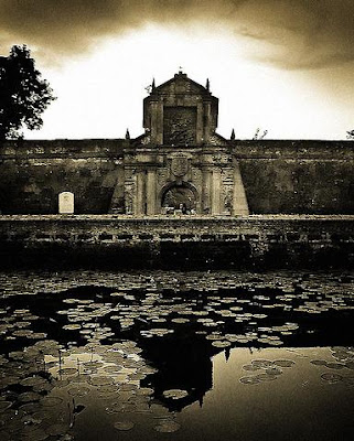
Intramuros (The Walled City)

The United States granted the country its full autonomy in 1946 but the city did not spring back to life. For many years, the city became an enormous wasteland overrun by squatters and depots. Container trucks roared through devastated streets, further damaging the ruined buildings and endangering the foundations of other centuries-old establishments.

In early seventies, despite the lack of funding, vast restoration projects of the walled city were implemented. Manila Cathedral was rebuilt and the Governor’s Palace has been reconstructed.

Intramuros slowly progressed and not long ago was transformed into a district of antiquity expositions, cafes, and a good nightlife destination.

Monday, September 8, 2008

Getting To Know: ANGELES, PAMPANGA


A View of Mt Arayat

LOCATED ON THE flat sandy lands of Pampanga, the city of Angeles can be easily reached through the North Expressway. Along the way, a lone volcano called Mt. Arayat is visibly rising in the middle of paddy fields of Magalang, east of Angeles. Contrary to how it looks from the outside, it has an interior of dense rainforest speckled with springs, streams and small falls. The trek to the summit offers stunning views of the central plains. The National Park has picnic areas equipped with swimming pools supplied by the free-flowing spring water of Mt. Arayat. To get there, take the north expressway , exit to Magalang and at the toll booth turn left with signs to Magalang, and Mt. Arayat National Park. Before heading up, you will be requested to register at the National Park Office. Bring enough supply of liquid for you and your guides. The trek starts from the Carabao logging trail to the interior passing through some springs and tiny falls. It takes about 7- 9 hours to reach the summit depending on your pace. Spend the night in the summit and head down the next day.

Crater lake of Mt. Pinatubo

After the massive eruption of the sleeping Mt. Pinatubo, several attractions within the area came out. Mountaineers and hikers in search for a diverse adventure bravely climb this delicate landform. Pinatubo trails vary all the time due to shifts in ground formations. Despite of uncertain conditions still Mt. Pinatubo is a favorite destination. On a fair weather, the hike is advised to start from Sapang Bato, a few km ride from the city. Then initiate from Target, an aeta resettlement area where you will be asked to register and pay a certain amount. A tour guide costs about 300Php and very necessary. It is best not to push through during rainy season. However the hike through lahar can be extremely dusty and exhausting during dry season. Be sure to have enough water supply as the trek might take time on steep areas. An inviting 2km wide crater lake of deep colored blue water awaits for a warm swim. This summit offers a commnanding views of the eroded terrains.