 A View of Mt Arayat
LOCATED ON THE flat sandy lands of Pampanga, the city of Angeles can be easily reached through the North Expressway. Along the way, a lone volcano called Mt. Arayat is visibly rising in the middle of paddy fields of Magalang, east of Angeles. Contrary to how it looks from the outside, it has an interior of dense rainforest speckled with springs, streams and small falls. The trek to the summit offers stunning views of the central plains. The National Park has picnic areas equipped with swimming pools supplied by the free-flowing spring water of Mt. Arayat. To get there, take the north expressway , exit to Magalang and at the toll booth turn left with signs to Magalang, and Mt. Arayat National Park. Before heading up, you will be requested to register at the National Park Office. Bring enough supply of liquid for you and your guides. The trek starts from the Carabao logging trail to the interior passing through some springs and tiny falls. It takes about 7- 9 hours to reach the summit depending on your pace. Spend the night in the summit and head down the next day.

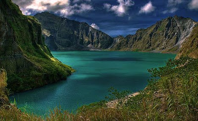
Crater lake of Mt. Pinatubo
After the massive eruption of the sleeping Mt. Pinatubo, several attractions within the area came out. Mountaineers and hikers in search for a diverse adventure bravely climb this delicate landform. Pinatubo trails vary all the time due to shifts in ground formations. Despite of uncertain conditions still Mt. Pinatubo is a favorite destination. On a fair weather, the hike is advised to start from Sapang Bato, a few km ride from the city. Then initiate from Target, an aeta resettlement area where you will be asked to register and pay a certain amount. A tour guide costs about 300Php and very necessary. It is best not to push through during rainy season. However the hike through lahar can be extremely dusty and exhausting during dry season. Be sure to have enough water supply as the trek might take time on steep areas. An inviting 2km wide crater lake of deep colored blue water awaits for a warm swim. This summit offers a commnanding views of the eroded terrains.

